A Shared Publication from the Hays County Master Naturalists
Reassessing Your Riparian Zone
Summer is a good time to observe your riparian zone and assess whether you have achieved the best balance between your needs and those of the waterway that flows past your property. Here are just some of questions you might want to ask yourself:
• How much of the riparian zone am I, my family, my guests actually using?
• Can we allow more areas to revegetate because we aren’t really using them?
• Does our pathway to the water need modification to control erosion or otherwise improve it?
• Do we want to improve the space(s) where we sit and enjoy watching the water flow?
• Do we need an easier way to get into the water to cool off?
But before you do anything, it’s a good idea to study your particular property and understand how your stretch of river or creek reacts to flood waters. As measured at the Ranch Road 12 bridge over the Blanco River, a “minor” flood is one that crests at between thirteen and seventeen feet. At thirteen feet, lowland flooding is enough to reach secondary roads in the floodplain and many low water crossings are impassable. The flood this past May crested at 14.57 feet and hopefully you made a mental note of where the water on your property came up to at the peak of that event.
Between seventeen and twenty-six feet, a flood is considered “moderate” at which point secondary roads in the floodplain become dangerous to motorists. As the flood level approaches twenty-five feet, the flow begins to approach low-lying homes in the Wimberley Valley and some are likely to flood. That’s what happened in the two major October floods when the water as measured at the Blanco bridge cresting at 26.54 feet in 2015 and 26.75 feet in 2013. Hopefully we won’t see another flood of that magnitude or more for at least another decade or two. But where the water crested during those two events is another point to note.
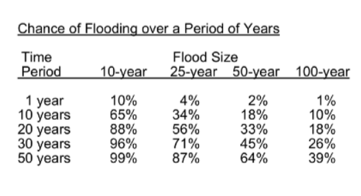
Flood size is often described in terms of years. But what exactly does that terminology mean? A 10- year flood has a 10% chance of occurring in a given year and a 99% chance of occurring within a period of fifty years. But there is no guarantee the same level will not occur a second time in the same or the following year. And there is a very small chance more than fifty years will pass before flooding reaches that level again.
RIPARIAN RECOVERY NETWORK NEWS Riparian: wetlands adjacent to rivers or streams
We often hear talk of the 100-year flood, also referred to as the “base flood” because it is a national standard that defines risk and is used for things like requiring the purchase of flood insurance and regulating new development. As such, the federal government avails itself of lots of scientific and engineering know-how to create maps designed to help communities understand what to expect if a 100-year flood hits their watershed. But these maps are also useful to individual property owners who want to understand how that level of flooding might affect them. You can locate your property on the most current official FEMA maps by going to https://msc.fema.gov/portal/home and entering your street address. 1
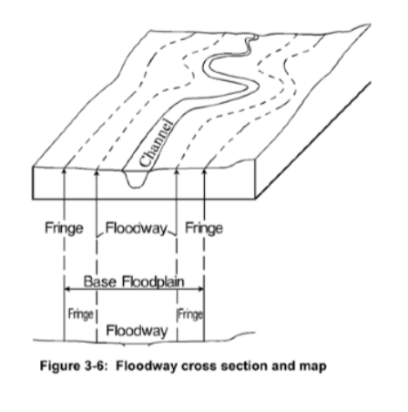
On the FEMA maps, you will see a hatched area which is the “regulated floodway.” The floodway is the stream channel plus that portion of adjacent land where the water will be deepest and swiftest in the event of a 100-year flood. Thus, development in the floodway is generally discouraged and, when allowed, the landowner must demonstrate that no rise in the base flood elevation (BFE) will occur. The remaining area of the floodplain, referred to as the fringe, is shown blue. In this area, water associated with the hypothetical 100-year flood will be shallower and slower moving. So generally, development in the fringe is allowed as long as the structure is elevated or otherwise protected to the base (i.e., 100-year) flood level. The third area shown in brown are is where very shallow flooding at depths less than one foot can be expected in a 100-year flood and that are likely to flood in a 500-year event.
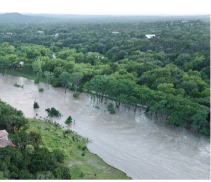
So now that you have all of this information, how can you use to assess your riparian zone. First this year’s flood is a good standard for the kind of flooding you should expect every few years. With such periodic inundations, native riparian vegetation will thrive, especially plants classified as obligate (OBL) or facultative wetland (FACW). Beyond just thriving though, vegetation in this area plays a significant role in both protecting and building up stream banks. Consider the picture at the left taken by a local homeowner as the Blanco began receding following our most recent flood. You can readily observe the impact of native vegetation by comparing the elevation of the flooded area with native vegetation vs. the neighboring mown property. So think of this area which is referred as the “riparian buffer zone” as the place on your property where you want the least amount of human incursion.
Now consider the areas of your property that are just above the riparian buffer zone. Those are the area still within the boundaries of the “regulated floodway” and the area of the floodplain that lies within the fringe. How much of your property these areas consume will vary significantly depending on topology. On steep slopes, these bands will be narrow while in flatter areas they can extend quite far beyond the normal stream channel. A good first step is to inspect those areas for bare ground and determine the cause. Looking upslope might well reveal that somewhere uphill run-off is being concentrated. So slowing/breaking up the flow and reseeding the eroded area may be the solution. Also check for invasive species and determine what action is warranted to eliminate/prevent the spread of unwanted plants.
Note the maps on this website are from 2005. New maps are in the process of being prepared. 1
The Blanco River Design Guidelines, developed by Lady Bird Johnson Wildflower staff with funding from Texas Parks and Wildlife, describes these areas as the “riparian canopy” because that is where pecans, cedar elms and other facultative (FAC) trees are found. These areas can also support grassy meadows filled with a wide variety of plants that tolerate both wet and dry conditions and feed the birds, butterflies and other wildlife you might want to attract to your property.
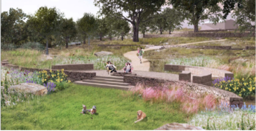
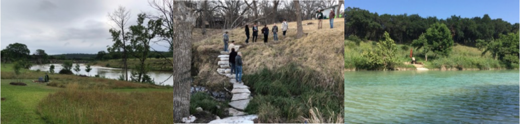
Finally, consider your destination spot, the place where you like to sit by yourself or with family/ guests, and the path that gets you there. Destination spots and access paths can be simple and inexpensive – all you need is a small mower or weed eater and a few chairs. You can improve these areas by spreading a seed mix containing some combination of short native grasses like buffalo, blue grama, and curly mesquite. Another trick is to mow both the pathway and destination spot higher (3-4 inches) as a way of encouraging plusher growth intermixed with horseherb and other forbs attractive to butterflies. Also consider the trajectory of your pathway. While shortest distance between two points is a straight line, a more sinuous path is not just more aesthetically pleasing, but also a good way to capture run-off more effectively.
Destination spots can include more elaborate, engineered structures. A steep slope may require steps. Or you may want to create a formal sitting area that includes a patio with steps to the water. But what you can and cannot build within the base floodplain is governed by rules designed to protect your property and your downstream neighbors. “Low-profile” decks and patios, defined by FEMA as having a “…vertical thickness … 12 inches or less, some of which may be below the adjacent finished grade,” must be constructed such that under flood conditions they will not create damaging debris. That means the deck/patio must either remain intact/in place or break apart into small enough pieces to assure the resulting debris doesn’t damage downstream structures. Railings must be open and seats, benches, tables, planters, or other obstructions must not be built into or attached to the structure.
Thus, projects involving construction within the floodplain take time to plan, obtain the required engineering study, and secure city or county approval. The rules can be complex and some are specific to the governing entity within which your property is located. Thus, both the City of Wimberley and Hays County encourage homeowners to bring them in early on before significant dollars have been spent on design plans or engineering studies.
For property within the City of Wimberley, the contact is Sandy Floyd, Planning and Development Coordinator, 512-847-0025 x25, sfloyd@cityofwimberley.com. If your property is in the Wimberly ETJ or unincorporated Hays County, the person you need to talk to is Caitlyn Strickland, Development Service Director, 512-393-2150, cstrickland@co.hays.tx.
The Riparian Recovery Network News is a periodic Hays County Master Naturalist publication covering topics of interest to the Wimberly Valley community. Please share this newsletter with friends and neighbors. Send any questions you might have or ideas for future topics to riparian@haysmn.org. And, if you are not currently on our mailing list, use this same address to request your name be added.